The Cammino runs along a ring of about 500 km in the south-west of Sardinia.
Almost 75% of the route is done on footpaths, dirt roads, cart and mule tracks, while the remaining 25% is made up of paved roads in the town centers and of brief tracts of asphalted streets on the outskirts of town.
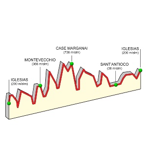
The altitude goes from sea level to a height of 900 m in the Marganai Mountain range: keep in mind there will be continuous differences in altitude, but only in some cases it could be particularly challenging. Depending on the length, level of difficulty and availability of accomodation facilities in the towns and mining villages you are passing through, the itinerary has been divided into 30 stages, with an average length of about 16 km each. Many stages are rather short, giving the pilgrim/excursionist time to visit classical industrial and archaeological sites of particular charm and beauty. Those not interested in the tours can easily divide the stages according to their taste and pace, taking availability of reception facilities into account.
We would also like to point out that the travel time indicated at the beginning of each stage is based on an average rate of 3 kilometers per hour, a slightly slower pace than the norm, precisely because the pilgrim/excursionist will want to slow down frequently to admire the scenery, particular geological formations, archaeological ruins or mining structures, as well as all the other beautiful sites he will encounter.
Attention: The “official guide” in some stretches, presents viability problems. These will gradually be taken care of through maintenance interventions. In the meantime, we prefer redirecting the walkers towards alternative and perfectly viable tracts as described on the website, indicated on the map with a red line, and marked on-site with temporary signposts (see signpost section).